
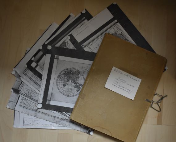
I was recently asked to go through a folder dating to the 1970s that had some time during the past decades found its way to the bookshelf of a colleague of mine. The folder contains notes and materials gathered by a lady called Hertta Tirranen that have been donated to a former professor of the history department. My colleague asked whether it looked like there was something worth keeping, and if so, would I have an interest in taking the materials. This was a tricky question to pose to someone with a keen interest in archives, both public and private.
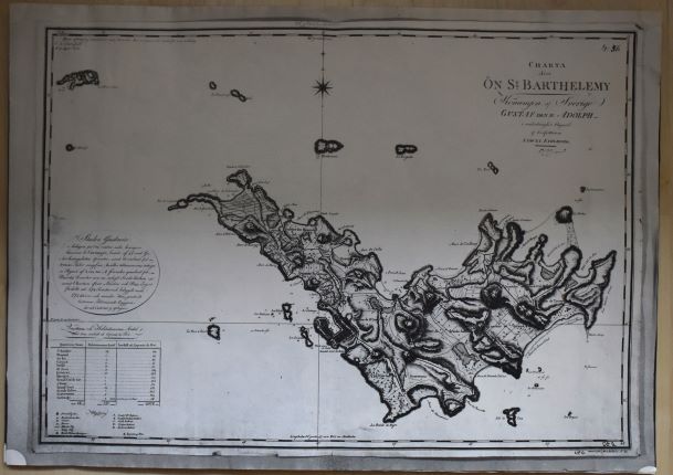
Indeed, what was there placed on the desk in front of us was “an archive” relating to the history of maps, mapping, and most likely in some way to otherness, European encounters with Africa and Asia. Hertta Tirranen, who was a Finnish editor, translator, and non-fiction author, had clearly gathered materials from multiple places, namely the National Library of Sweden, for a project of hers – the objects of which we did not know. Consequently, the folder includes copies of maps, illustrations, as well as order slips from orders made at the Swedish Kungliga biblioteket in 1970 and some notes. The materials gathered by Hertta include, for instance, Anders Åkerman’s Atlas juvenilis, a publication containing originally approximately 20 maps and first published in 1768. The publication was later taken over by Daniel Djurberg, and Hertta also made copies of Djurberg’s issue of the atlas with imprints of 1818. Moreover, there are copies of maps by Samuel Fahlberg depicting the Swedish island of Saint Barthélemy in 1799, engraved in 1801 in Stockholm. In addition to maps, Hertta had collected different types reproductions of images of African people from different sources, including photographic slides and microfiche.
As we went through the contents of the folder, we wondered: what had Hertta been working on and what type of archive was this? Could it be analysed in some productive way? I promised to look into the story of Hertta, and the making of this “archive” and thought that this blog would be the perfect place to share my reflections about this collection of different types of copies of old maps.
In 1970, at the time she was making copies of the various maps she examined in Sweden, Hertta, born in 1915, would have been 55. She was still probably working at the Werner Södeström Oy where she had for years partook, for instance, in the making of books focusing on art and artists. The archive of the Finnish National Gallery includes a collection donated by Hertta, which contains biographical information about numerous Finnish artists that she undoubtedly accumulated during her career in the publishing world.
However, my inquiries about Hertta’s interests in the history of mapping did not lead to any clues about what she was working towards when she was ordering and copying maps in Stockholm. Presently, however, I have been unable to peruse the correspondence materials stretching from 1969 to 1974 that she has left behind in the archives of WSOY. These may help uncover the meaning of Hertta’s “archive” that is currently in my possession. Perhaps Hertta was planning a book on European mapping of Africa and Asia? She obviously had an interest in the Swedish Åkerman, Djurberg and Fahlberg, but what did she infer from their mappings?
The usefulness of Hertta’s archive from a scholarly perspective, of course, depends on what type of story one hopes to tell. Even if we cannot uncover what Hertta’s project was, the copies she has made and the materials she has pulled together provoke interesting questions when discussed in the context of the object biographies and the social lives of maps that have become popular approaches to the study of maps and mapping as part of the wider turn towards post-representational analysis of the spatial work that maps have done in the past.[1] Indeed, considered in this context, Hertta’s reproductions of the maps by Åkerman, Djurberg, Fahlberg, and others have provided these maps a new life-stage; as copies they have created a new material representation of the original and enabled their user to take themselves with her whilst leaving the originals at the archive.
The copies thus function as extensions of the original – they are clear indicators that these maps were meaningful for Hertta and she had a relationship with the maps she studied. Replicating the maps at the archive were a means to “take the maps back home”; thus, the copy can be seen as a means of mobilizing the contents of the otherwise immobile maps that have become institutionalized. This perspective is interesting as it coincides with what Filipe dos Reis has noted in his recent article focusing on German mapmaker Augustus Petermann. Building on Bruno Latour and John Law and Annemarie Mol, dos Reis argues for the need to acknowledge that maps can be simultaneously many things: they can be immutable mobiles, mutable mobiles, immutable immobiles, and mutable immobiles depending on their contexts of use.[2]
Consequently, it is not enough to think about maps as immutable mobiles – as things that are able to move without changing as Latour noted in 1987 in his classic Science in action.[3] Rather approaching mapping as a process and investigating the social lives of the material maps requires acknowledgement of the diverse ways that maps can become mobilized (including copying), how they can be fluctuating and prone to change as people use them for diverse purposes. Simultaneously, at some point they may become immobile and their appearances frozen – thus transforming into an immutable immobile, for example in the hands of an archivist or a collector, for example. In situations where the material map is destroyed, replications of it may take the place of the original map. Consequently, when the context changes, the meanings of the maps are likely to change, and they also become subject to being changed in their appearance too. Even when the maps are archived, things may be added to them; an institutional stamp, a pencilled number indicating their place in the archive and so on.
Moreover, this marginal archive of copies of maps and images collected by Hertta many decades ago, highlights the changing research practices that digitalization has introduced. Certainly, encountering Hertta’s archive reminded me of similar archive of another map scholar working in the 1970s, that of Coolie Verner, a Canadian professor of education who was interested in the maps of the English mapmakers, the Arrowsmiths. I came across Verner’s archive whilst researching the work of the last owner of the family firm, John Arrowsmith. I perused the notes that Verner had gathered when trying to contextualize the maps of North America that John Arrowsmith’s uncle Aaron Arrowsmith had started to publish in the late 18th century. Verner’s archive contains copies of letters written to different archivist asking for information about this and that map, as well as their replies. In addition, one can find the hand-written manuscripts Verner wrote while pulling all the information together to produce published articles and copies of maps that Verner utilised in his research. Reading through these materials made evident how much historical scholarship has changed in fifty years: we only rarely use land mail to make enquiries to the archives and usually we now study digital replications of the maps rather than the smudgy black-and-white photocopy reproductions of them. Indeed, Hertta’s archive is also a material reminder of the changes that have occurred in the technologies of reproducing maps as well as in the practices of researching old maps. Many of us now enjoy 24/7 access to them from the comfort from of our own homes and offices.
[1] E. g. Martin Brückner, The Social Life of Maps in America, 1750-1860 (Williamsburg & Chapel Hill: Omohundro Institute of Early American History and Culture and the University of North Carolina Press, 2017); Christian J. Koot, A Biography of a Map in Motion: Augustine Herrman’s Chesapeake (New York: New York University Press, 2018); Luis Lobo-Guerro, Laura Lo Presti, and Filipe dos Reis, eds., Mapping, Connectivity and the Making of European Empires, Global Epistemics (Lanham: Rowman & Littlefield, 2021).
[2] Filipe dos Reis, “Empires of Science, Science of Empires: Mapping, Centres of Calculation and the Making of Imperial Spaces in Nineteenth-Century Germany,” in Mapping, Connectivity and the Making of European Empires (Lanham: Rowman & Littlefield, 2021), 105–38.
[3] Bruno Latour, Science in Action: How to Follow Scientists and Engineers Through Society (Harvard University Press, 1987).
