Together with my colleagues, we have for several years worked on this anthology on the history of knowledge and it is now finished and published. Tiedonhistoria (Vastapaino 2023) introduces the field of the history of knowledge to the Finnish audiences. The volume contemplates what it means to study knowledge historically, how the history of knowledge expands our perspectives about past ways of knowing and what type of possibilities and challenges relate to this type of research. The book includes a comprehensive introduction and eleven chapters that elaborate on these questions.
In addition to the introduction, I contributed to the volume a chapter that emphasizes how historians of knowledge should in their work carefully contemplate the approaches and concepts developed by historians of colonialism and colonial knowledge.
Sain taannoin mahdollisuuden kirjoittaa arkistojen käyttämisestä ja järjestetyn arkiston tärkeydestä tutkijalle arkistoalan asiantuntijan, MetaManagerin, Asiakirjatyypit-blogiin. Kirjoitukseni “Järjestetty arkisto on tutkijan onni” on luettavissa täällä.
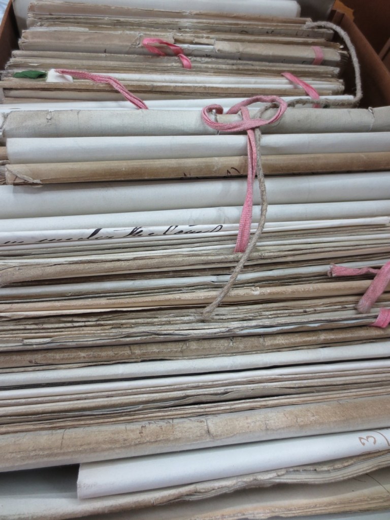
Kuva kirjeaineistoista, joita tutkin ensimmäisellä arkistomatkallani Britannian kansallisarkistoon.
Hot off the press is my contribution to an edited collection entitled Finnish Settler Colonialism in North America: Rethinking Finnish Experiences in Transnational Spaces (Helsinki University Press 2022), edited by Rani-Henrik Andersson and Janne Lahti. The book and its contributions seek to reexamine Finns in North America by situating them in the context of global settler colonialism. For the book I wrote an article that examines what popular geographical publications, published at the end of the nineteenth and early decades of the twentieth century, reveal about the shaping of Finnish geohistorical imaginations concerning the roles of Finns in settling the United States. The article examines how, why, and what types of maps and geographical knowledge were utilized to document and represent the historical roots of Finns in America and make them visible on the map of the United States. I argue that the geographical texts and maps were tools for Finns and Finnish Americans to make claims for spaces on the North American terrain and to showcase how they too had contributed to “civilizing” the lands and building the settler colonial society, past and present. I contextualize the maps and geographical texts within the colonial cartographic frame where the roles of Europeans as “discoverers” were emphasized and Indigenous land use and geographical knowledge became marginalized.
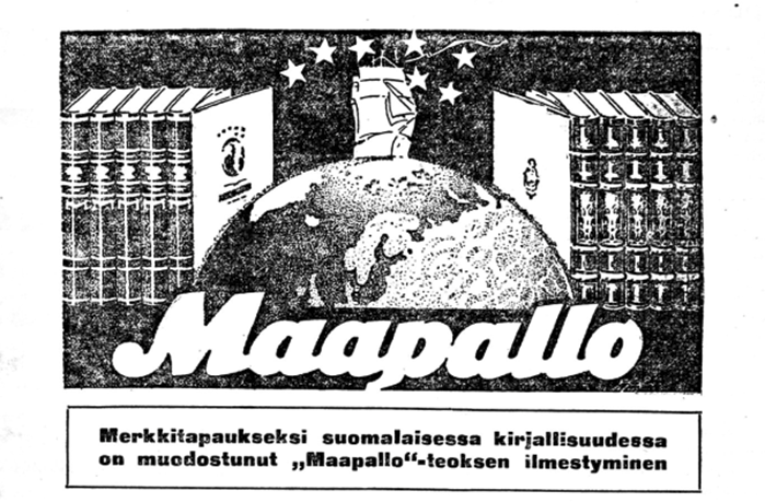
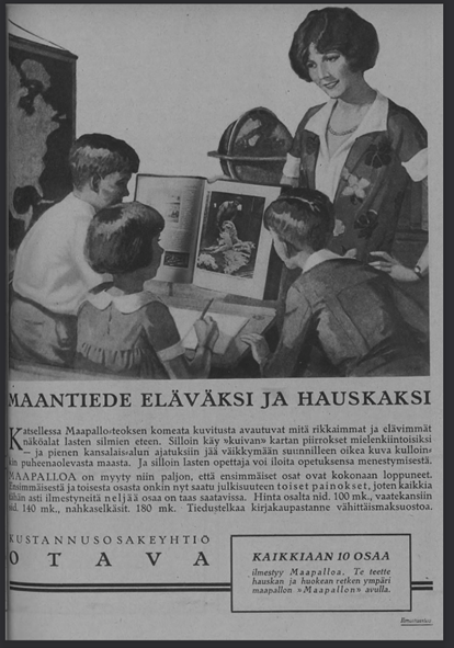
Viime viikolla esittelin Tampereella Historiantutkimuksen päivillä tutkimusta, joka liittyy Otavan 1920-luvulla julkaisemaan Maapallo-tietokirjasarjaan. Kyseessä on runsaasti kuvitettu kymmenosainen kirjasarja, jonka toimittivat maantieteen professori Johan E. Rosberg ja maantieteilijätaustainen Viljo Tolvanen, joka työskenteli Otavan maantieteellisen kirjallisuuden kustannustoimittajana. Teoksen valmistamisen taustalla oli ajatus valistaa juuri itsenäistynyttä Suomen kansaa ja opettaa heitä tuntemaan maailma ja sen suomalaisille tarjoamat mahdollisuudet.
Johan E. Rosbergin ja Viljo Tolvasen Maapallo-teossarjan mainos, Otava, 1923.
Teossarjan ensimmäinen osa oli omistettu yleisille näkökohdille. Sen jälkeen liikkeelle lähdettiin maapallon kaukaisista kolkista: napa-alueista ja Australiasta. Seuraavissa osissa käytiin läpi muita kaukaisempia alueita ja viimeiset osat keskittyivät Eurooppaan. Kirjasarjassa tavallaan edettiin sivistymättömimmistä alueista kohti sivistyneempiä maanosia, päätyen lopulta viimeisen osan viimeisessä luvussa Suomeen. Keskeistä ja kiinnostavaa kirjasarjassa on, että siihen kontribuoi runsas joukko kirjoittajia (yhteensä 70 eri henkilöä), joista monille, muttei kaikilla, oli erilaisia yhteyksiä paikkoihin ja maihin, joista he kirjoittivat. Maapallo havainnollistaa siten maailmaa koskevan tiedon yhteenkokoamista erilaisista lähteistä ja sen esittämistä suurta yleisöä puhuttelevassa muodossa.
Samalla teossarjan moniäänisyys herättää kysymyksiä siitä, millaisten kohtaamisten ja vuorovaikutusten sekä kopiointien ja käännösten kautta Maapallon sivuille painettiin tietynlaiset kuvaukset kaukaisista maailmankolkista. Teossarja usuttaa kysymään, mitä on globaali tieto ja miten sen muodostumista voidaan tutkia? Millaisesta tiedosta tulee globaalia ja miksi? Esitelmässäni pyrinkin havainnollistamaan, että Maapallon kautta on mahdollista pohtia kuinka maantieteellisen tiedon historia suomalaisessa yhteiskunnassa linkittyy osaksi globaaleita tietorakenteita ja mitä Maapallo kertoo näiden tietorakenteiden ja tietämisen tapojen liikkumisesta.
Nämä näkökohdat ovat tärkeitä pohdittaessa kysymyksiä, jotka liittyvät maantieteellisen tiedon positionaalisuuteen ja laajemmin kysymyksiin globaalin tiedon sijoittuneisuudesta. Maantieteellisen tiedon ja ajattelun historiassa on jo kolmen vuosikymmenen ajan pyritty moninaistamaan näkökulmaa maantieteen historiasta – kyseessä ei ole yksi vaan monta historiaa.[1] Viimeisen vuosikymmenen aikana erityisesti kysymys maantieteellisen tiedon liikkumisesta on tullut tärkeäksi näkökulmaksi: tutkijoita kiinnostavat prosessit, joiden kautta tieto liikkuu toimijalta toiselle, ja miten esimerkiksi kentällä tehdyt havainnot jalostuvat julkaistuiksi teoksiksi.[2] Olennaisia ovat myös kysymykset eri toimijoiden rooleista näissä prosesseissa: keneltä tietoa on kerätty, kenen äänet pääsevät kuuluviin ja miten. Maantieteen historia on pitkään ollut varsin valkoista ja eurosentristä ja tätä näkökulmaa on haluttu moninaistaa nostamalla esiin arkistoista aiemmin sivuutettuja ja marginalisoituja ääniä. Tämä pätee erityisesti eurooppalaisen tutkimusmatkailun historiaan.[3]
Kysymykset maantieteellisen tiedon positionaalisuudesta ja tiedon kierrosta ovat tärkeitä, kun tarkastellaan tieteen popularisointia ja niin sanottua julkista tietoa. Tiedon kierto käsitteenä auttaa hahmottamaan paitsi tiedon liikkumista maantieteellisesti myös materiaalisia ja sosiaalisia prosesseja, jotka vaikuttavat tietoon. Yksi osa tiedon kierron tutkimusta on tiedon julkisuuteen liittyvät kysymykset: millaiset asiat tulivat laajasti jaetuiksi ja missä muodossa? Nimenomaan kysymys tiedon muodosta on tärkeä, sillä popularisoitu ja julkisesti jaettu tieto liikkuvat tiettyjen välineiden kuten vaikka kirjojen kautta. Andreas Daum on ehdottanut, että popularisoitu tiede tulisi ymmärtää osana laajempaa julkisesti jaetun tiedon kokonaisuutta. Julkisesti jaetussa tiedossa olennaista on Daumin mukaan kysymys tiedon legitimiteetistä.[4] Laajasti jaetun tiedon syntyminen taas linkittyy kysymykseen globaalista tiedosta: millä tavoin tieto voi olla globaalia ja tietyt tietorakenteet saada laajan legitimiteetin? Diarmid Finnegan ja Jonathan Wright määrittelevät globaalin tiedon toisaalta maailmaa koskevaksi tiedoksi mutta toisaalta myös tiedon muodoksi, joka liikkuu ympäri maailmaa. Tiedon liike ympäri maailmaa taas linkittyy tiettyjen toimijoiden intresseihin ja valtapositioihin joiden kriittinen tarkastelu paljastaa globaalin tiedon sijoittuneisuuden ja muuntumisen sen siirtyessä kontekstista toiseen, esim. kun tietoa julkaistaan. [5]Maapallon kontekstissa nämä intressit ja valtapositiot linkittyvät koloniaalisiin tietämisen tapoihin ja koloniaaliseen maailmanjärjestykseen, jossa tietyt toimijat ja heidän tulkintansa maailmasta marginalisoitiin.
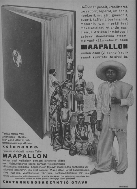
Maapallon viidennen osan mainos Suomen Kuvalehdessä 31.3.1926
Teossarjan moniäänisyys ja siinä esitettyjen tietojen sijoittuneisuus ei rajoittunut sen suurilukuiseen kirjoittajakuntaan, joka koostui niin diplomaateista, tieteentekijöistä, lähestystyöntekijöistä, opettajista, toimittajista, maantieteilijöistä ja kirjailijoista. Huhupuheiden ja toisen käden tietojen muodossa Maapallon sivuilta löytyy useita esimerkkejä alkuperäiskansojen tiedosta: siitä, miten kohtaamiset joko suomalaisten tai muiden eurooppalaisten kanssa johtivat siihen, että tietyt tulkinnat maailmasta löysivät tiensä Suomessa julkaistun tietokirjasarjan sivuille. Nämä tekevät Maapallosta mielenkiintoisen tutkimuskohteen, sillä tiedon kopioitumisen, kääntämisen ja suodattumisen ketjujen tarkastelu paljastaa globaalin tiedon muodostumisen dynamiikan. Samalla konkretisoituu kuinka tiedon paikoin hyvin monimutkainen kierto materiaalisesta muodosta toiseen – matkamuistiinpanosta painetuksi kirjaksi – pohjustaa tiedon muuntumista yksilöä laajemmaksi ilmiöksi.
Esitelmässäni esittelin ensimmäisiä havaintojani teossarjasta – sen 3500 sivua takaavat, että tutkittavaa ja analysoitavaa riittää. Menetelmällisesti tärkeä havainto onkin, että lähilukemalla eri osien kirjoituksia on mahdollista havainnoida millaisista erilaisista lähteistä kirjan kirjoittajat ja toimittajista erityisesti Tolvanen, joka johti käytännön toimitustyötä, tietoa maailmasta suomalaisille koostivat. Havainnollinen esimerkki ovat kirjoihin painetut kartat, jotka koottiin erilaisista lähteistä – mukana on erikielisiä karttoja, mutta suomenkielisiä, selkeästi kirjasarjaa varten valmistettuja karttoja on eniten. Eri konteksteista peräisin olevien karttojen sisällyttäminen Maapalloon kertoo mielenkiintoisella tavalla paitsi tiedon prosessuaalisesta luonteesta myös karttojen ja tekstien elämänkaarista: osana suomalaista tietokirjasarjaa tiettyä tarkoitusta varten alunperin painetut kartat asetettiin uuteen kontekstiin, havainnollistamaan erilaiselle yleisölle kyseisen alueen maantiedettä.
Maapallon mainos Suomen Kuvalehdessä 6.3.1926.
[1] David N. Livingstone, The Geographical Tradition: Episodes in the History of a Contested Enterprise (Blackwell, 1993); David N. Livingstone, Putting Science in Its Place: Geographies of Scientific Knowledge (Chicago: The University of Chicago Press, 2003).
[2] Innes M. Keighren and Charles W.J. Withers, “Questions of Inscription and Epistemology in British Travelers’ Accounts of Early Nineteenth-Century South America,” Annals of the Association of American Geographers 101, no. 6 (2011): 1331–46; Innes M. Keighren, Charles W. J. Withers, and Bill Bell, Travels into Print : Exploration, Writing, and Publishing with John Murray, 1773-1859 (Chicago: The University of Chicago Press, 2015).
[3] Keighren, Withers, and Bell, Travels into Print : Exploration, Writing, and Publishing with John Murray, 1773-1859; Dane Kennedy, The Last Blank Spaces. Exploring Africa and Australia (Cambridge: Harvard University Press, 2013); Shino Konishi, Maria Nugent, and Shellam Tiffany, eds., Indigenous Intermediaries. New Perspectives on Exploration Archives (Acton ACT: ANU Press and Aboriginal History Inc., 2015).
[4] Andreas W. Daum, “Varieties of Popular Science and the Transformations of Public Knowledge: Some Historical Reflections,” Isis 100, no. 2 (2009): 319–32, https://doi.org/10.1086/599550.
[5] Diarmid A. Finnegan and Jonathan Jeffrey Wright, “Placing Global Knowledge in the Nineteenth Century,” in Spaces of Global Knowledge : Exhibition, Encounter and Exchange in an Age of Empire, ed. Diarmid A Finnegan and Jonathan Jeffrey Wright, Studies in Historical Geography (Farnham: Ashgate, 2015), 1–18.
August is here and with it comes the anticipation of the start of a new academic year. Therefore, it is perfect moment to reflect on the past year and how I have progressed with my research. I am currently two-thirds into my current project – September will mark the beginning of the final year. The past two years have been shadowed by the pandemic – prohibiting or postponing many of my planned travels abroad. However, as most of the primary sources that I am studying are located in Finland, I have been able to proceed with my research almost as planned. Due to the restricted opening hours and limited seats at the archives, working with some material has been incredibly slow and forced me to find alternative perspectives using digitized materials. This has led to many interesting discoveries, especially regarding how different types of maps were discussed in the press, how they were marketed and what types of maps were available during the different decades of the latter half of the nineteenth and the early twentieth century.
Indeed, newspapers and periodicals are an incredibly rich source to understand the availability of different types of maps and geographical publications, to understand what their relative prices were and who may have purchased them. One example that I have researched during the past year are the maps that were incorporated in specialized periodicals such as those published by the Finnish Missionary Society for children and adults. These maps, the reading instructions, and the geographical information that was distributed with them shed light on the ways that institutions other than schools shaped people’s geographical imaginations and map literacy. Another case study that I have focused on is the ten-volume-book-series called Maapallo, that was published in the 1920s by Otava, a major Finnish publishing house. In this case too, the reviews in the press and the advertising of the volumes that are available digitally provided something to work with while accessing the sources in the archives was difficult.
In addition to this short summary of the past year and the topics I have research, I want to highlight two important events that took place in May-July regarding the history of maps and cartography. The first is the course on the history of maps and mapping that I organized at the Open University at the University of Helsinki. The lecture course featured multiple lecturers and students got an introduction to the historical study of maps and mapping. The course was held in hybrid mode, although after the first lecture most students chose to follow the course via Zoom. This was the first time that put together a course on this theme and chose to approach the topic from a variety of different perspectives. These included past and current approaches to the study of maps and cartography, medieval maps and world views (taught by Stefan Schröder), Renaissance maps and atlases (taught by Marjo T. Nurminen), different types of early modern maps of the Finnish maps and their revelance to archeological research (taught by Georg Haggrén), Indigenous maps (taught by Joy Slappnig), maps, colonialism and European empires (taught by myself), maps in war (taught by Erkki-Sakari Harju) and maps and imagined communities (taught by myself). A mixed collection of themes that reflected the expertise of the lecturers.
During the course, students were assigned readings and mini studies of maps. I also organized them to visit a map exhibition either live or online. The goal of these smaller assignments was to support the students learning during the course and inspire them to find the topic of the final assignment, which was a research essay on the map or maps or their choice. From the teacher’s perspective, this structure seemed to work well, and some students confirmed this in their feedback. For others, according to their feedback, this seemed to make the course too heavy.
Looking back at the course and how it unfolded during summer weeks from early May to the Midsummer in June, my first impression is the difficulty of how to approach such a wide topic. My own expertise covers only a portion of the theme. Relying on knowledgeable colleagues is therefore crucial. However, based on my experience from this course, the topic would benefit from a more hands-on approach alongside the lectures that give the context and present theoretical perspectives. Perhaps I should next develop a practical course on map history. One student hoped for a course on the maps and mapping of Finland and the Nordic countries – such a theme is a possibility too. Now, I am still eagerly waiting for the final essays from the students. Reading these will show me what the students have learned about the studying the history of maps and mapping.
The other event worthy of noting is of course the 29th International Conference on the History of Cartography, which was held in Bucharest, Romania on the first week of July. The ICHC’s are the only conferences dedicated entirely to the history of maps, mapping and cartography. The theme of this year’s conference was conflict and cartography, a well-suited topic that allowed for the study of maps from various periods and contexts. At the conference, I had the great opportunity to share my research on the Finnish Missionary Society’s world maps, and as always, to learn from other people’s research. Even though the hybrid format had its challenges, it was great to be able to participate remotely. I do, however, look forward to participating the next conference in person!
Participating the ICHC 2022 from the home office had its benefits.
Pääsin kertomaan tämän hetkisestä tutkimushankkeestani Maantieteellinen tieto suomalaisessa yhteiskunnassa Sanojen liike -podcastissa. Juttutuokiossa Janne Tunturin kanssa käydään läpi hankkeen tavoitteita, taustoja ja tähänastisia tuloksia. Jakso on kuunneltavissa Spotifyssa.
I wrote a review article for the Finnish open access journal Ennen ja nyt: historian tietosanomat on the postrepresentational, processual and biographical approaches to the study of maps and mapping. The article analyses three recent publications concerned with these approaches, namely Christian J. Koot’s A biography of a map in motion: Augustine Hermann’s Chesapeake (New York University Press, 2018), Martin Brückner’s The Social lives of maps in America, 1750–1850 (Omohundro Institute of Early American History and Culture and the University of North Carolina Press, 2017) and Mapping, connectivities and themaking of European Empires (Rowman & Littlefield, 2021), edited by Luis Lobo-Guerro, Laura Lo Presti, and Filipe dos Reis.
The article (in Finnish) is available open access here.
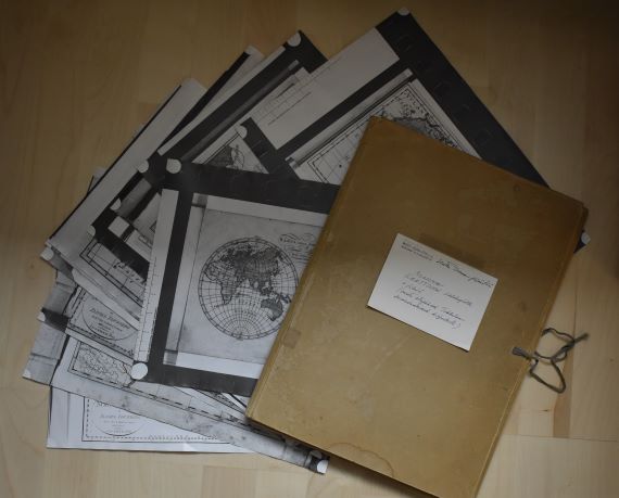
I was recently asked to go through a folder dating to the 1970s that had some time during the past decades found its way to the bookshelf of a colleague of mine. The folder contains notes and materials gathered by a lady called Hertta Tirranen that have been donated to a former professor of the history department. My colleague asked whether it looked like there was something worth keeping, and if so, would I have an interest in taking the materials. This was a tricky question to pose to someone with a keen interest in archives, both public and private.
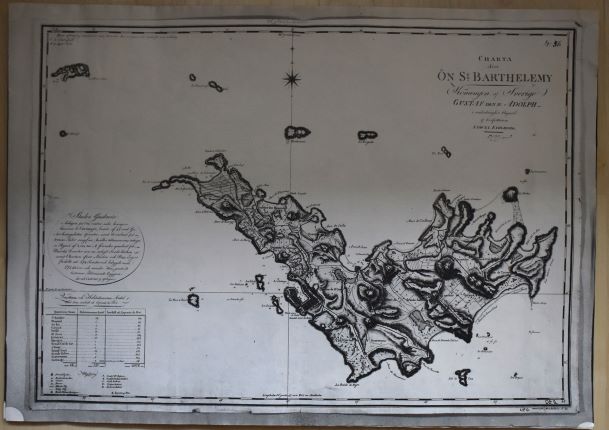
Indeed, what was there placed on the desk in front of us was “an archive” relating to the history of maps, mapping, and most likely in some way to otherness, European encounters with Africa and Asia. Hertta Tirranen, who was a Finnish editor, translator, and non-fiction author, had clearly gathered materials from multiple places, namely the National Library of Sweden, for a project of hers – the objects of which we did not know. Consequently, the folder includes copies of maps, illustrations, as well as order slips from orders made at the Swedish Kungliga biblioteket in 1970 and some notes. The materials gathered by Hertta include, for instance, Anders Åkerman’s Atlas juvenilis, a publication containing originally approximately 20 maps and first published in 1768. The publication was later taken over by Daniel Djurberg, and Hertta also made copies of Djurberg’s issue of the atlas with imprints of 1818. Moreover, there are copies of maps by Samuel Fahlberg depicting the Swedish island of Saint Barthélemy in 1799, engraved in 1801 in Stockholm. In addition to maps, Hertta had collected different types reproductions of images of African people from different sources, including photographic slides and microfiche.
Hertta Tirranen’s “archive” of old maps, described by someone from WSOY as a collection of “photocopies and microfiche of world maps”. Photo by author.
As we went through the contents of the folder, we wondered: what had Hertta been working on and what type of archive was this? Could it be analysed in some productive way? I promised to look into the story of Hertta, and the making of this “archive” and thought that this blog would be the perfect place to share my reflections about this collection of different types of copies of old maps.
In 1970, at the time she was making copies of the various maps she examined in Sweden, Hertta, born in 1915, would have been 55. She was still probably working at the Werner Södeström Oy where she had for years partook, for instance, in the making of books focusing on art and artists. The archive of the Finnish National Gallery includes a collection donated by Hertta, which contains biographical information about numerous Finnish artists that she undoubtedly accumulated during her career in the publishing world.
However, my inquiries about Hertta’s interests in the history of mapping did not lead to any clues about what she was working towards when she was ordering and copying maps in Stockholm. Presently, however, I have been unable to peruse the correspondence materials stretching from 1969 to 1974 that she has left behind in the archives of WSOY. These may help uncover the meaning of Hertta’s “archive” that is currently in my possession. Perhaps Hertta was planning a book on European mapping of Africa and Asia? She obviously had an interest in the Swedish Åkerman, Djurberg and Fahlberg, but what did she infer from their mappings?
The usefulness of Hertta’s archive from a scholarly perspective, of course, depends on what type of story one hopes to tell. Even if we cannot uncover what Hertta’s project was, the copies she has made and the materials she has pulled together provoke interesting questions when discussed in the context of the object biographies and the social lives of maps that have become popular approaches to the study of maps and mapping as part of the wider turn towards post-representational analysis of the spatial work that maps have done in the past.[1] Indeed, considered in this context, Hertta’s reproductions of the maps by Åkerman, Djurberg, Fahlberg, and others have provided these maps a new life-stage; as copies they have created a new material representation of the original and enabled their user to take themselves with her whilst leaving the originals at the archive.
Photocopy of Samuel Fahlberg’s map of the Swedish island of Saint Barthélemy in 1799 in Hertta’s archive. Photo by author.
The copies thus function as extensions of the original – they are clear indicators that these maps were meaningful for Hertta and she had a relationship with the maps she studied. Replicating the maps at the archive were a means to “take the maps back home”; thus, the copy can be seen as a means of mobilizing the contents of the otherwise immobile maps that have become institutionalized. This perspective is interesting as it coincides with what Filipe dos Reis has noted in his recent article focusing on German mapmaker Augustus Petermann. Building on Bruno Latour and John Law and Annemarie Mol, dos Reis argues for the need to acknowledge that maps can be simultaneously many things: they can be immutable mobiles, mutable mobiles, immutable immobiles, and mutable immobiles depending on their contexts of use.[2]
Consequently, it is not enough to think about maps as immutable mobiles – as things that are able to move without changing as Latour noted in 1987 in his classic Science in action.[3] Rather approaching mapping as a process and investigating the social lives of the material maps requires acknowledgement of the diverse ways that maps can become mobilized (including copying), how they can be fluctuating and prone to change as people use them for diverse purposes. Simultaneously, at some point they may become immobile and their appearances frozen – thus transforming into an immutable immobile, for example in the hands of an archivist or a collector, for example. In situations where the material map is destroyed, replications of it may take the place of the original map. Consequently, when the context changes, the meanings of the maps are likely to change, and they also become subject to being changed in their appearance too. Even when the maps are archived, things may be added to them; an institutional stamp, a pencilled number indicating their place in the archive and so on.
Moreover, this marginal archive of copies of maps and images collected by Hertta many decades ago, highlights the changing research practices that digitalization has introduced. Certainly, encountering Hertta’s archive reminded me of similar archive of another map scholar working in the 1970s, that of Coolie Verner, a Canadian professor of education who was interested in the maps of the English mapmakers, the Arrowsmiths. I came across Verner’s archive whilst researching the work of the last owner of the family firm, John Arrowsmith. I perused the notes that Verner had gathered when trying to contextualize the maps of North America that John Arrowsmith’s uncle Aaron Arrowsmith had started to publish in the late 18th century. Verner’s archive contains copies of letters written to different archivist asking for information about this and that map, as well as their replies. In addition, one can find the hand-written manuscripts Verner wrote while pulling all the information together to produce published articles and copies of maps that Verner utilised in his research. Reading through these materials made evident how much historical scholarship has changed in fifty years: we only rarely use land mail to make enquiries to the archives and usually we now study digital replications of the maps rather than the smudgy black-and-white photocopy reproductions of them. Indeed, Hertta’s archive is also a material reminder of the changes that have occurred in the technologies of reproducing maps as well as in the practices of researching old maps. Many of us now enjoy 24/7 access to them from the comfort from of our own homes and offices.
[1] E. g. Martin Brückner, The Social Life of Maps in America, 1750-1860 (Williamsburg & Chapel Hill: Omohundro Institute of Early American History and Culture and the University of North Carolina Press, 2017); Christian J. Koot, A Biography of a Map in Motion: Augustine Herrman’s Chesapeake (New York: New York University Press, 2018); Luis Lobo-Guerro, Laura Lo Presti, and Filipe dos Reis, eds., Mapping, Connectivity and the Making of European Empires, Global Epistemics (Lanham: Rowman & Littlefield, 2021).
[2] Filipe dos Reis, “Empires of Science, Science of Empires: Mapping, Centres of Calculation and the Making of Imperial Spaces in Nineteenth-Century Germany,” in Mapping, Connectivity and the Making of European Empires (Lanham: Rowman & Littlefield, 2021), 105–38.
[3] Bruno Latour, Science in Action: How to Follow Scientists and Engineers Through Society (Harvard University Press, 1987).
As explained in the previous post, in September-October 2021 I taught a lecture course “Knowledge and Science in the European Empires in the 19th Century: Expeditions, Collections and Biopolitics” at the University of Helsinki. The focus of the course was on the importance of knowledge and science in the internal and interplay of European empires in the 19th century. During the course, we looked at the role of expeditions, scientific institutions, museums and various collections in producing information about European colonies and their inhabitants. In addition, we examined the role of different disciplines (such as geography, medicine, and ethnography) and discussed the knowledge practices that grounded the governance of the overseas territories.
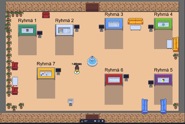
One of the main tasks for the students during the course was to prepare a scientific poster and a video presentation in groups. As the course was held online, I organized a virtual poster session where students had the opportunity to listen to each other’s presentations and get to know the posters of the other groups. Therefore, in addition to relying on Zoom for the main part of the course, I utilised a platform called GatherTown to organize the poster session. In this post I describe the key issues that relate to organizing a virtual poster session.
Gather Town as a platform for a virtual poster session
The course consisted of seven thematic lectures for which students did six preliminary assignments. After the lecture part, the course moved on to group work, with the aim of making a poster of a free-choice topic related to the course theme and preparing a ten-minute presentation that they recorded. During the group work phase of the course, I booked one separate time to allow students to participate in a virtual poster session on the Gather Town platform.
Gather Town is a browser-based virtual environment where participants can move around the space created by the organizer; in the context of this course this was a poster room created for a poster session. During the corona pandemic, Gather has been used, for example, as a platform for conference poster sessions and also as a free-form discussion area. I chose Gather Town because 1) I didn’t want to have the presentations on Zoom, but rather 2) allow students to listen to the presentations at their own pace and 3) support the development of students’ skills in pre-recording the presentations.
Gather Town was also suitable to try on this course because the platform in question is free for groups of less than 25 people. For larger user groups, the platform charges different fees.
Gather Town does not record the sessions of its users or sell the information provided during the deployment of the platform to third parties. The more detailed security and privacy guidelines can be found here.
The basic requirement for using Gather is that you create a room that has poster walls and screens for listening and watching the presentations, topped with the amount of furniture, flowers and other elements of your choosing. The poster room is probably one of the simplest spaces that can be created and the hardest part in designing it is deciding where to place the necessary elements. Quite easy!
Each user navigates in that room with a virtual character (avatar) that they have to create and name when joining the platform. There is plenty to choose from in terms of characters – I ended up with a character wearing a top hat. When users move around the room they can chat with each other once they are close enough. Likewise, the users are able to view the posters and listen to the presentations when they move close enough to the poster wall or the screen. It would also be possible for users to share a screen and connect a video call, for example, but I did not use these features myself during the course.
Image 1: The top-hatted teacher waits for students to arrive in the poster room. The posters have been placed to the poster boards and the presentations have been linked to the screens. The students are able to view and listen to them once they step close enough. Screen shot: Johanna Skurnik
For the needs of the course, I created a small room where I could easily place the seven posters made during the course. I uploaded the posters to the poster walls in image format (jpg / png). I linked the pre-recorded MP4 presentations to separate screens. To upload the videos, I asked the students to return them to the folder I created on OneDrive, from where I uploaded them to Vimeo (Youtube is another option). The videos had to be uploaded to Vimeo because Gather requires that you link the videos to the platform – so you do not upload them to Gather. It is also possible to have the poster presentations live at Gather Town, thus avoiding the need to upload them to Vimeo or Youtube. I kept the videos secret in Vimeo and removed them from the service at the end of the course.
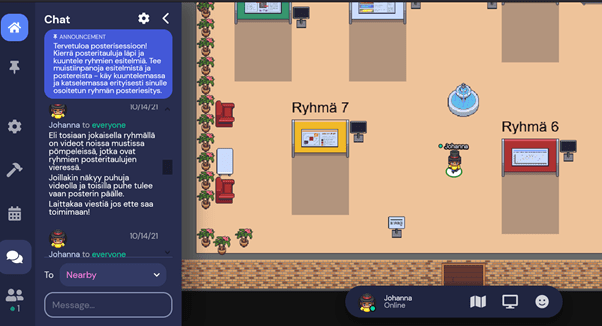
Students join the poster session by clicking an invitation link that I sent them (it is possible to set an additional password). You can set an expiration date for the invitation link: I set the room open for seven days. The student who receives the invitation link transfers to the room you have created after a short tutorial, which will provide sufficient information to navigate the spaces created on the platform. There is a chat channel on the platform where you can chat with students individually or send a message to everyone in the room.
In the poster session, students could tour the room at their own pace, watching posters and listening to presentations, and talking to each other and the teacher. Since the room was open for a week, students were able to return there to listen to presentations even after the poster session.
Image 2: The platform has a chat that you can use to message everyone or individual participants. Screen shot: Johanna Skurnik.
Feedback and experiences
After the poster session, we went through the posters during one Zoom session, where each group gave feedback to another group and received feedback on their own poster and presentation. To help with the feedback, the students had a poster and presentation evaluation matrix and a related set of questions. In addition to oral feedback, students also use Moodle’s workshop function to evaluate their own and others posters. In this way, the course provided practice in giving and receiving feedback and developing the students’ self-assessment skills on several occasions. I believe these assignments helped students internalize points related to communicating information effectively (e.g., what visualization works and what does not, what is the relationship between presentation and poster, how to crystallize information, etc.).
Based on the feedback gathered during the course and the overall course feedback, students seemed to like the poster as a task and considered Gather Town to be a fun learning environment. Students said the platform is easy to use and a nice variation on Zoom. From a teacher’s perspective, guiding the making of posters as well as trying out a new kind of virtual platform was refreshing. Prior to this course, I had no previous experience with Gather Town, but I found using the platform easy and it worked reliably.
The biggest challenge in utilizing Gather Town in teaching relates to its costs if you have a class of more than 24. Gather Town is suitable for teaching smaller groups without any problems, but if it is a larger group, the room will indeed become chargeable. There is also a charge for using Vimeo. However, if the poster session is live, there is no need to link videos to Gather Town, which helps you avoid the payment problem.
The student presentations and posters were of high quality and most students seemed to enjoy making them. I would definitely use Gather Town again and would recommend it to others if there you have a need for a slightly different virtual learning environment.
In September-October 2021 I am teaching an undergraduate course on the history of knowledge and science in nineteenth-century European empires. The course is organized at the history unit at the University of Helsinki. Due to the on-going pandemic, it is held online. The purpose of the course is to introduce students to the complex relationship between the production of knowledge, the development of the sciences and the expansion of the European empires in the 19th century. The course tackles the topic thematically as we examine exploring expeditions, processes of mapping and surveying as well as collecting and exhibiting artefacts and specimens in museums and exhibitions. In addition, the topics addressed include analysing the empires as multispecies entities and thinking about the globally significant environmental changes that the European colonial projects brought about. Finally, what would a course on European empires and knowledge be if it did not pay attention to the role of paper and documents in transfering knowledge across the seas? Therefore the final topic discussed is concerned with the bureaucratic and documentary administrative practices that grounded the governance of the overseas territories. Throughout the course I highlight the significance and implications of knowledge exchanges between Europeans and the different Indigenous peoples and offer examples of how to trace marginalized voices from the colonial archives.
This is the first time I am teaching this course so it is something of an experiment. The course work consists of written assignments, class discussions and group work and are designed to develop the students’ abilities to assess their own learning processes. In groups the students will prepare scientific posters and present to the rest of the class in online poster sessions – I am very much looking forward to how this will work and what the students think of this. Come October, we shall see!