Pääsin kertomaan tämän hetkisestä tutkimushankkeestani Maantieteellinen tieto suomalaisessa yhteiskunnassa Sanojen liike -podcastissa. Juttutuokiossa Janne Tunturin kanssa käydään läpi hankkeen tavoitteita, taustoja ja tähänastisia tuloksia. Jakso on kuunneltavissa Spotifyssa.
Category Archives: Uncategorized
New publication on “maps on the move”
I wrote a review article for the Finnish open access journal Ennen ja nyt: historian tietosanomat on the postrepresentational, processual and biographical approaches to the study of maps and mapping. The article analyses three recent publications concerned with these approaches, namely Christian J. Koot’s A biography of a map in motion: Augustine Hermann’s Chesapeake (New York University Press, 2018), Martin Brückner’s The Social lives of maps in America, 1750–1850 (Omohundro Institute of Early American History and Culture and the University of North Carolina Press, 2017) and Mapping, connectivities and themaking of European Empires (Rowman & Littlefield, 2021), edited by Luis Lobo-Guerro, Laura Lo Presti, and Filipe dos Reis.
The article (in Finnish) is available open access here.
The mystery of Hertta’s archive of copied old maps
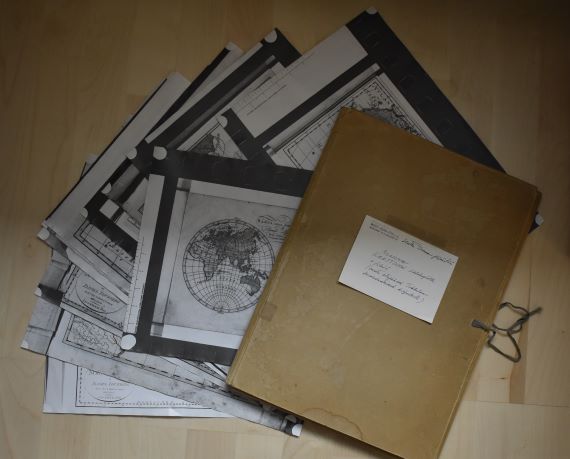
I was recently asked to go through a folder dating to the 1970s that had some time during the past decades found its way to the bookshelf of a colleague of mine. The folder contains notes and materials gathered by a lady called Hertta Tirranen that have been donated to a former professor of the history department. My colleague asked whether it looked like there was something worth keeping, and if so, would I have an interest in taking the materials. This was a tricky question to pose to someone with a keen interest in archives, both public and private.
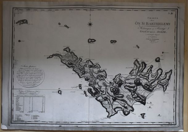
Indeed, what was there placed on the desk in front of us was “an archive” relating to the history of maps, mapping, and most likely in some way to otherness, European encounters with Africa and Asia. Hertta Tirranen, who was a Finnish editor, translator, and non-fiction author, had clearly gathered materials from multiple places, namely the National Library of Sweden, for a project of hers – the objects of which we did not know. Consequently, the folder includes copies of maps, illustrations, as well as order slips from orders made at the Swedish Kungliga biblioteket in 1970 and some notes. The materials gathered by Hertta include, for instance, Anders Åkerman’s Atlas juvenilis, a publication containing originally approximately 20 maps and first published in 1768. The publication was later taken over by Daniel Djurberg, and Hertta also made copies of Djurberg’s issue of the atlas with imprints of 1818. Moreover, there are copies of maps by Samuel Fahlberg depicting the Swedish island of Saint Barthélemy in 1799, engraved in 1801 in Stockholm. In addition to maps, Hertta had collected different types reproductions of images of African people from different sources, including photographic slides and microfiche.
As we went through the contents of the folder, we wondered: what had Hertta been working on and what type of archive was this? Could it be analysed in some productive way? I promised to look into the story of Hertta, and the making of this “archive” and thought that this blog would be the perfect place to share my reflections about this collection of different types of copies of old maps.
In 1970, at the time she was making copies of the various maps she examined in Sweden, Hertta, born in 1915, would have been 55. She was still probably working at the Werner Södeström Oy where she had for years partook, for instance, in the making of books focusing on art and artists. The archive of the Finnish National Gallery includes a collection donated by Hertta, which contains biographical information about numerous Finnish artists that she undoubtedly accumulated during her career in the publishing world.
However, my inquiries about Hertta’s interests in the history of mapping did not lead to any clues about what she was working towards when she was ordering and copying maps in Stockholm. Presently, however, I have been unable to peruse the correspondence materials stretching from 1969 to 1974 that she has left behind in the archives of WSOY. These may help uncover the meaning of Hertta’s “archive” that is currently in my possession. Perhaps Hertta was planning a book on European mapping of Africa and Asia? She obviously had an interest in the Swedish Åkerman, Djurberg and Fahlberg, but what did she infer from their mappings?
The usefulness of Hertta’s archive from a scholarly perspective, of course, depends on what type of story one hopes to tell. Even if we cannot uncover what Hertta’s project was, the copies she has made and the materials she has pulled together provoke interesting questions when discussed in the context of the object biographies and the social lives of maps that have become popular approaches to the study of maps and mapping as part of the wider turn towards post-representational analysis of the spatial work that maps have done in the past.[1] Indeed, considered in this context, Hertta’s reproductions of the maps by Åkerman, Djurberg, Fahlberg, and others have provided these maps a new life-stage; as copies they have created a new material representation of the original and enabled their user to take themselves with her whilst leaving the originals at the archive.
The copies thus function as extensions of the original – they are clear indicators that these maps were meaningful for Hertta and she had a relationship with the maps she studied. Replicating the maps at the archive were a means to “take the maps back home”; thus, the copy can be seen as a means of mobilizing the contents of the otherwise immobile maps that have become institutionalized. This perspective is interesting as it coincides with what Filipe dos Reis has noted in his recent article focusing on German mapmaker Augustus Petermann. Building on Bruno Latour and John Law and Annemarie Mol, dos Reis argues for the need to acknowledge that maps can be simultaneously many things: they can be immutable mobiles, mutable mobiles, immutable immobiles, and mutable immobiles depending on their contexts of use.[2]
Consequently, it is not enough to think about maps as immutable mobiles – as things that are able to move without changing as Latour noted in 1987 in his classic Science in action.[3] Rather approaching mapping as a process and investigating the social lives of the material maps requires acknowledgement of the diverse ways that maps can become mobilized (including copying), how they can be fluctuating and prone to change as people use them for diverse purposes. Simultaneously, at some point they may become immobile and their appearances frozen – thus transforming into an immutable immobile, for example in the hands of an archivist or a collector, for example. In situations where the material map is destroyed, replications of it may take the place of the original map. Consequently, when the context changes, the meanings of the maps are likely to change, and they also become subject to being changed in their appearance too. Even when the maps are archived, things may be added to them; an institutional stamp, a pencilled number indicating their place in the archive and so on.
Moreover, this marginal archive of copies of maps and images collected by Hertta many decades ago, highlights the changing research practices that digitalization has introduced. Certainly, encountering Hertta’s archive reminded me of similar archive of another map scholar working in the 1970s, that of Coolie Verner, a Canadian professor of education who was interested in the maps of the English mapmakers, the Arrowsmiths. I came across Verner’s archive whilst researching the work of the last owner of the family firm, John Arrowsmith. I perused the notes that Verner had gathered when trying to contextualize the maps of North America that John Arrowsmith’s uncle Aaron Arrowsmith had started to publish in the late 18th century. Verner’s archive contains copies of letters written to different archivist asking for information about this and that map, as well as their replies. In addition, one can find the hand-written manuscripts Verner wrote while pulling all the information together to produce published articles and copies of maps that Verner utilised in his research. Reading through these materials made evident how much historical scholarship has changed in fifty years: we only rarely use land mail to make enquiries to the archives and usually we now study digital replications of the maps rather than the smudgy black-and-white photocopy reproductions of them. Indeed, Hertta’s archive is also a material reminder of the changes that have occurred in the technologies of reproducing maps as well as in the practices of researching old maps. Many of us now enjoy 24/7 access to them from the comfort from of our own homes and offices.
[1] E. g. Martin Brückner, The Social Life of Maps in America, 1750-1860 (Williamsburg & Chapel Hill: Omohundro Institute of Early American History and Culture and the University of North Carolina Press, 2017); Christian J. Koot, A Biography of a Map in Motion: Augustine Herrman’s Chesapeake (New York: New York University Press, 2018); Luis Lobo-Guerro, Laura Lo Presti, and Filipe dos Reis, eds., Mapping, Connectivity and the Making of European Empires, Global Epistemics (Lanham: Rowman & Littlefield, 2021).
[2] Filipe dos Reis, “Empires of Science, Science of Empires: Mapping, Centres of Calculation and the Making of Imperial Spaces in Nineteenth-Century Germany,” in Mapping, Connectivity and the Making of European Empires (Lanham: Rowman & Littlefield, 2021), 105–38.
[3] Bruno Latour, Science in Action: How to Follow Scientists and Engineers Through Society (Harvard University Press, 1987).
Teaching with virtual posters: experiences from a course on the history of knowledge and science
As explained in the previous post, in September-October 2021 I taught a lecture course “Knowledge and Science in the European Empires in the 19th Century: Expeditions, Collections and Biopolitics” at the University of Helsinki. The focus of the course was on the importance of knowledge and science in the internal and interplay of European empires in the 19th century. During the course, we looked at the role of expeditions, scientific institutions, museums and various collections in producing information about European colonies and their inhabitants. In addition, we examined the role of different disciplines (such as geography, medicine, and ethnography) and discussed the knowledge practices that grounded the governance of the overseas territories.
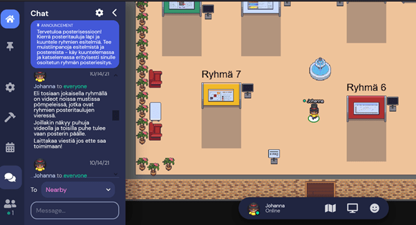
One of the main tasks for the students during the course was to prepare a scientific poster and a video presentation in groups. As the course was held online, I organized a virtual poster session where students had the opportunity to listen to each other’s presentations and get to know the posters of the other groups. Therefore, in addition to relying on Zoom for the main part of the course, I utilised a platform called GatherTown to organize the poster session. In this post I describe the key issues that relate to organizing a virtual poster session.
Gather Town as a platform for a virtual poster session
The course consisted of seven thematic lectures for which students did six preliminary assignments. After the lecture part, the course moved on to group work, with the aim of making a poster of a free-choice topic related to the course theme and preparing a ten-minute presentation that they recorded. During the group work phase of the course, I booked one separate time to allow students to participate in a virtual poster session on the Gather Town platform.
Gather Town is a browser-based virtual environment where participants can move around the space created by the organizer; in the context of this course this was a poster room created for a poster session. During the corona pandemic, Gather has been used, for example, as a platform for conference poster sessions and also as a free-form discussion area. I chose Gather Town because 1) I didn’t want to have the presentations on Zoom, but rather 2) allow students to listen to the presentations at their own pace and 3) support the development of students’ skills in pre-recording the presentations.
Gather Town was also suitable to try on this course because the platform in question is free for groups of less than 25 people. For larger user groups, the platform charges different fees.
Gather Town does not record the sessions of its users or sell the information provided during the deployment of the platform to third parties. The more detailed security and privacy guidelines can be found here.
The basic requirement for using Gather is that you create a room that has poster walls and screens for listening and watching the presentations, topped with the amount of furniture, flowers and other elements of your choosing. The poster room is probably one of the simplest spaces that can be created and the hardest part in designing it is deciding where to place the necessary elements. Quite easy!
Each user navigates in that room with a virtual character (avatar) that they have to create and name when joining the platform. There is plenty to choose from in terms of characters – I ended up with a character wearing a top hat. When users move around the room they can chat with each other once they are close enough. Likewise, the users are able to view the posters and listen to the presentations when they move close enough to the poster wall or the screen. It would also be possible for users to share a screen and connect a video call, for example, but I did not use these features myself during the course.
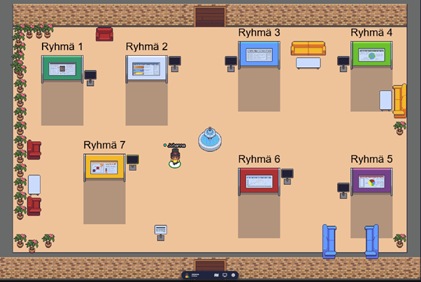
For the needs of the course, I created a small room where I could easily place the seven posters made during the course. I uploaded the posters to the poster walls in image format (jpg / png). I linked the pre-recorded MP4 presentations to separate screens. To upload the videos, I asked the students to return them to the folder I created on OneDrive, from where I uploaded them to Vimeo (Youtube is another option). The videos had to be uploaded to Vimeo because Gather requires that you link the videos to the platform – so you do not upload them to Gather. It is also possible to have the poster presentations live at Gather Town, thus avoiding the need to upload them to Vimeo or Youtube. I kept the videos secret in Vimeo and removed them from the service at the end of the course.
Students join the poster session by clicking an invitation link that I sent them (it is possible to set an additional password). You can set an expiration date for the invitation link: I set the room open for seven days. The student who receives the invitation link transfers to the room you have created after a short tutorial, which will provide sufficient information to navigate the spaces created on the platform. There is a chat channel on the platform where you can chat with students individually or send a message to everyone in the room.
In the poster session, students could tour the room at their own pace, watching posters and listening to presentations, and talking to each other and the teacher. Since the room was open for a week, students were able to return there to listen to presentations even after the poster session.
Feedback and experiences
After the poster session, we went through the posters during one Zoom session, where each group gave feedback to another group and received feedback on their own poster and presentation. To help with the feedback, the students had a poster and presentation evaluation matrix and a related set of questions. In addition to oral feedback, students also use Moodle’s workshop function to evaluate their own and others posters. In this way, the course provided practice in giving and receiving feedback and developing the students’ self-assessment skills on several occasions. I believe these assignments helped students internalize points related to communicating information effectively (e.g., what visualization works and what does not, what is the relationship between presentation and poster, how to crystallize information, etc.).
Based on the feedback gathered during the course and the overall course feedback, students seemed to like the poster as a task and considered Gather Town to be a fun learning environment. Students said the platform is easy to use and a nice variation on Zoom. From a teacher’s perspective, guiding the making of posters as well as trying out a new kind of virtual platform was refreshing. Prior to this course, I had no previous experience with Gather Town, but I found using the platform easy and it worked reliably.
The biggest challenge in utilizing Gather Town in teaching relates to its costs if you have a class of more than 24. Gather Town is suitable for teaching smaller groups without any problems, but if it is a larger group, the room will indeed become chargeable. There is also a charge for using Vimeo. However, if the poster session is live, there is no need to link videos to Gather Town, which helps you avoid the payment problem.
The student presentations and posters were of high quality and most students seemed to enjoy making them. I would definitely use Gather Town again and would recommend it to others if there you have a need for a slightly different virtual learning environment.
Introducing project “Producing and mobilizing geographical knowledge in Finnish society”
After enjoying numerous walks by the Brighton seafront and the South Downs in East Sussex since January 2019, in August 2020 I returned to Finland to start a new postdoctoral project titled Producing and mobilizing geographical knowledge in Finnish society, c. 1850-1940 at the University of Helsinki. The three-year project, funded by the Academy of Finland, enables me to dive into the piles of maps, atlases and geographical texts that enabled Finns to know the world beyond Europe during a period when only the few had the opportunity to travel and explore these areas in person.
One of the inspirations for the project was my somewhat random encounter with the first Finnish language map of the world on the website of Kotimaisten kielten keskus. The map, published in 1845, appeared as a supplement to the first volume of Lukemisia Suomen Kansan hyödyksi, a series edited by journalist Paavo Tikkanen. The map was published with an article that provided its readers an introduction to general geography (Johdatus Yleiseen Maa-tietoon). The first Finnish map of Europe had been published only some twenty years before in 1821, also as a supplement. This map appeared in Turun Wiikko-Sanomat, a magazine published in southern Finland by Reinhold von Becker.
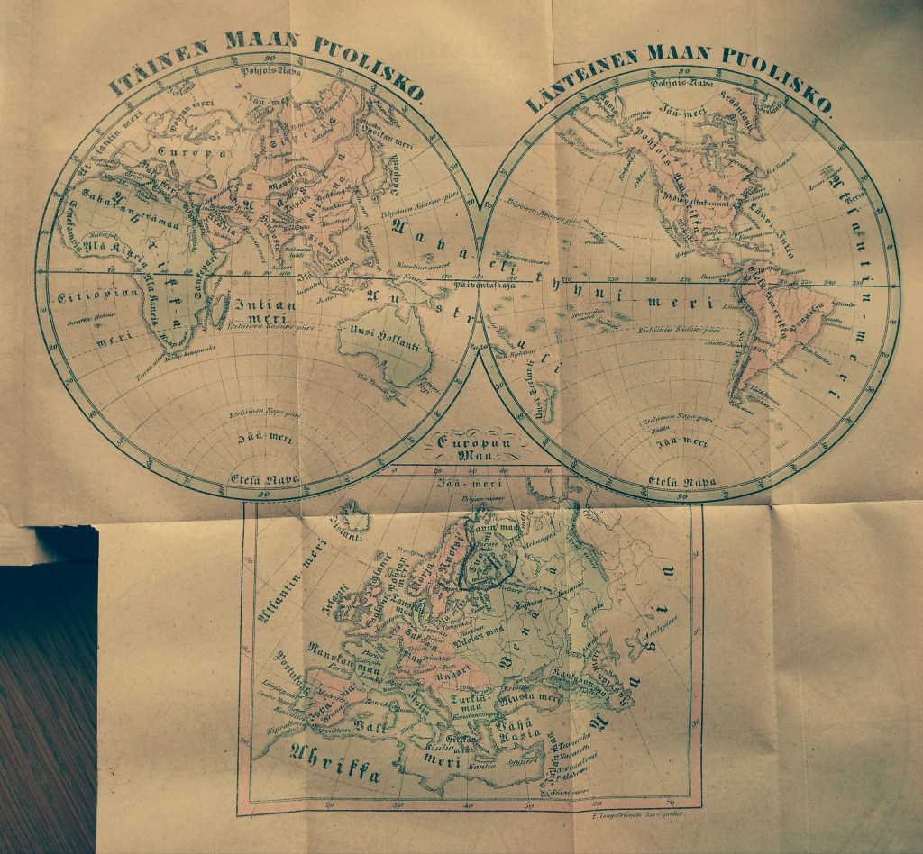
When zooming in and out the world map and reading through Tikkanen’s introduction of world geography, I began to wonder about the people who had perused the map in the 1840s and travelled the contours of the world with its help. I wondered how many cut out the map, as Tikkanen suggested, and pinned it on a wall to study it later in reference to everything else they came to know about the distant parts of the globe? What did they learn about these places, how, where and why?
These questions guided me in developing a research proposal that combines together perspectives from the history of knowledge, historical geography, material culture research and the study of print culture to examine the changes and continuities in the geographical imaginations in Finnish society. The period I am concerned with, roughly between the 1850s and the 1903s included the expansion of European empires, the growth of the global protestant missionary project (which the Finns partook with their own Finnish Missionary Society), the establishment of geographical societies (the Finnish Geographical Society was founded in 1888) and Finnish mass-migrations especially to North America. Mass-education was introduced, with the growth of mass-literacy. Cheaper printing technologies and new methods of documenting the world (especially photography) transformed the ways of transmitting knowledge. Literary Finnish developed into its modern form during the nineteenth century, and Finland gained its independence from the Russian Empire in 1917. All these historical processes had their impact on the geographical knowledges that were produced and mobilized in different forms in the Finnish society.
In addition to blogging about the general progress of my research, I will be posting separate “object biographies” concerning some of the maps, globes, books and atlases that I encounter during my work. I am looking forward to sharing with you what I find as my project advances!
First post: Fascinated by ways of knowing
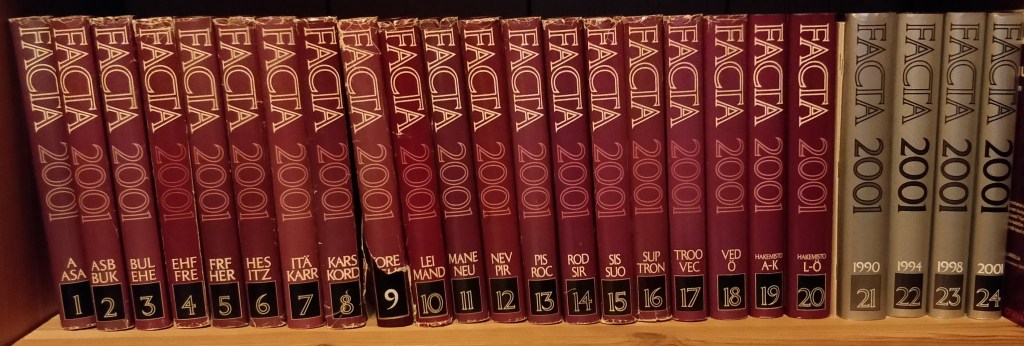
As long as I recall, I have been fascinated with different ways of organizing knowledge concerning the world. In my childhood I remember picking up volumes of an encyclopedia or pouring myself over the Reader’s Digest atlas of the world my parents had. I especially loved reading about different types of animals – and Ethiopia! Of course back then I had no idea that these books were about that – ways of knowing. For me they signified the way of knowing and the things to know.
Since the 1990s I have learned to appreciate the multivolume encyclopedia Facta as a way of knowing. Importantly, my studies in history and geography inspired me to make it my daily job to research how people in the past have known the world and what they have utilized this knowledge for. This site is dedicated for reflecting my explorations with these questions.